
COROBOR – MESSIR-AERO
Your needs Pilots as well as airline companies need to know the flight meteorological conditions for take-off , en-route and landing. Weather information is essential to the safety and regularity of air navigation. Severe weather conditions can lead to flight delays, disasters and human losses. Weather information is necessary at each step of a flight: Before the flight, the observed or expected weather may lead to delay the flight, change route, cancel the flight. For take-off and landing, the pilot must be informed of poor visibility on the runway, gust wind, wind shear, heavy precipitations… Along the flight path, the pilot must be informed in advance about turbulence areas, location of cumulonimbus clusters, jets (strong winds), the risk of icing, volcanic ash, warnings issued by the Met services of the countries overflown during the flight. To be able to provide an exhaustive briefing on current and forecasted weather conditions, the Airport Meteorological Service needs a Pilot MET briefing system. What is MESSIR-AERO? MESSIR-AERO is the ideal Pilot MET briefing system. MESSIR-AERO software allows the most demanding Airport Meteorological Services to:
- Acquire SADIS WAFS data from WAFC London
- Acquire WIFS WAFS data from WAFC Washington
- Acquire other useful data and products from various data sources (MSS as MESSIR-COMM, local AWOS, satellite and radar imagery, wind shear alerts)
- Store these data online to keep them at the immediate disposal of Pilots and Airline companies
- Produce automatically Meteorological Flight Folders
Description
MESSIR-AERO Main Functions
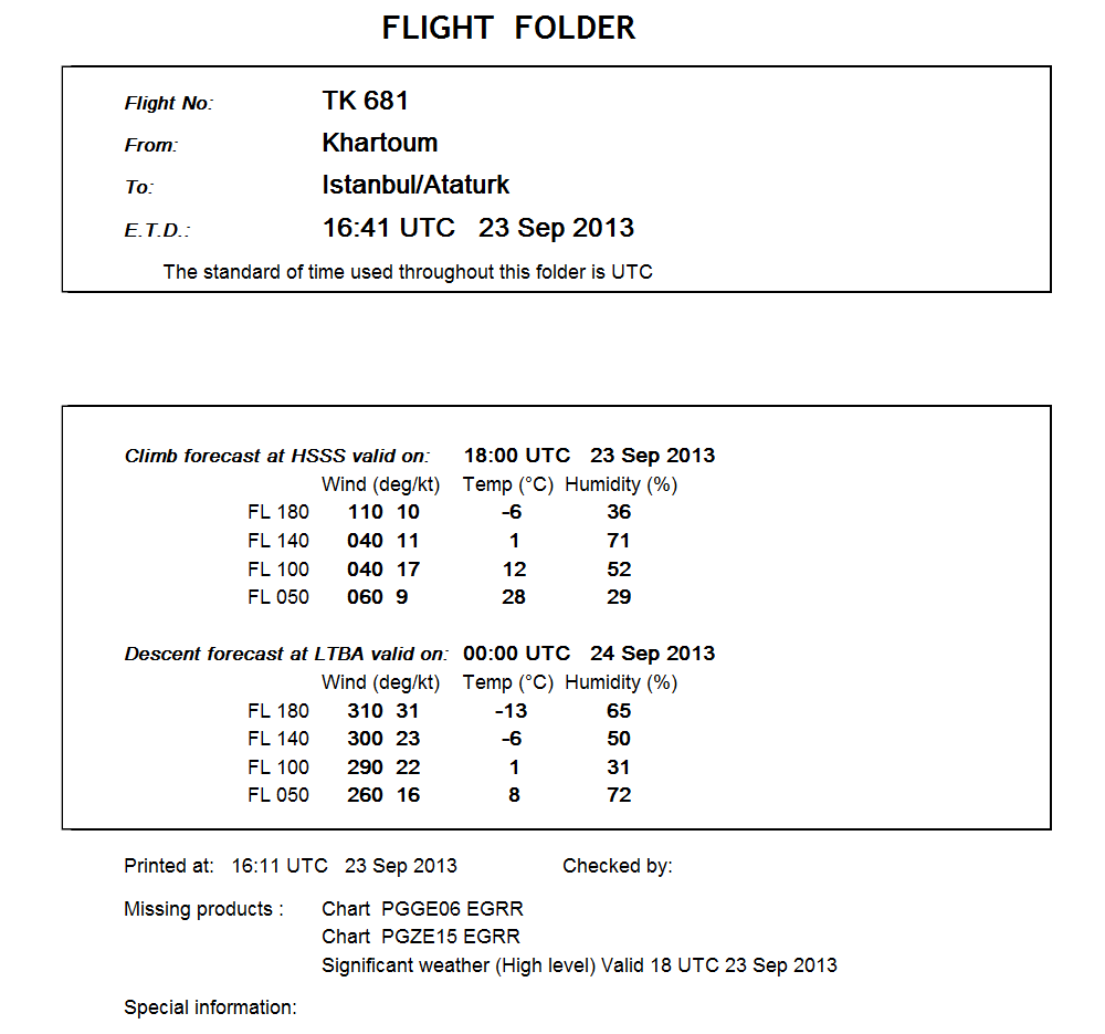
MESSIR-AERO automatically produces meteorological flight folders as required by ICAO Annex 3 (“Meteorological Service for International Air Navigation”):
- Forecasts for take-off
- Forecasts for upper wind and upper-air temperature, upper-air humidity, geopotential altitude of flight levels, flight level and temperature of tropopause, direction, speed and flight level of maximum wind, SIGWX (Significant weather) phenomena
- METAR, SPECI, TAF for the airport of departure, airport of destination, en-route and destination alternate airports
- SIGMET information and appropriate special air-reports relevant to the whole route
 MESSIR-AERO Key Features
- Compliance with ICAO Annex 3 and latest amendments
- OPMET data, text as well as BUFR and XML : METAR, TAF, SPECI, SIGMET, AIRMET…
- Implements the WMO/ICAO Aviation Data Exchange Model AvXML for ingesting and storing OPMET data received as XML
- WAFS data received from WAFC London through the SADIS satellite broadcast or from SADIS Secure FTP server
- WAFS data received from WAFC Washington through the WIFS (World Area Forecast System Internet File Service) webcast
- METAR / TAF colour codes for easy monitoring of regional conditions
- Audio and visual alerts upon reception of urgent advisories: Volcanic Ash, Cyclone Advisories…
- GRIB/GRIB2 forecast charts: Wind, temperature, humidity, pressure, tropopause height, icing, turbulence, CAT, CBs…
- Vertical cross section along the flight path
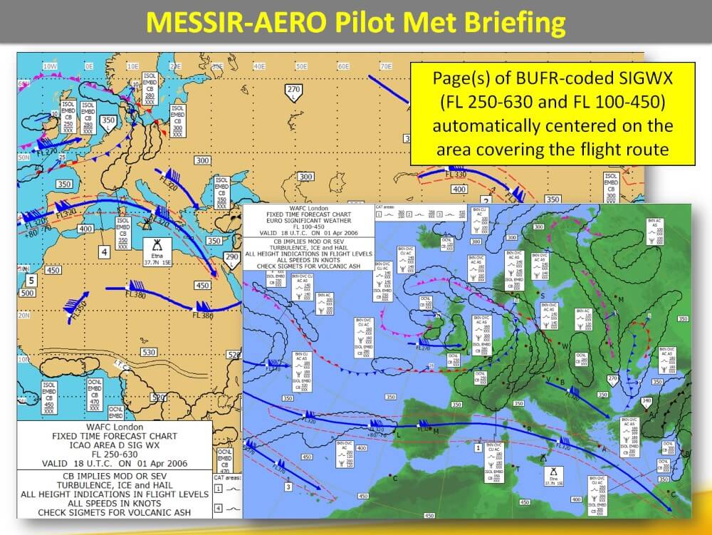
- Medium and High level SIGWX forecast charts from BUFR and PNG image data
- Automatic generation of SIGWX charts from BUFRs, on ICAO standard areas as well as on user-defined specific geographical areas (via the MESSIR-ImageMaker module)
- Automatic generation of Wind-Temp charts from GRIBs, on ICAO standard areas as well as on user-defined specific geographical areas
- TAF verification including automatic comparison with METAR and alerts triggering
- Message editing and quality control. Message entry forms for TAF, METAR, SIGMET…
- Possible access through Web Portal
- Remote sensing Imagery (Satellite, Radar, Wind shear, Lightning impacts) integration
- Automatic preparation of flight folders from FPL messages received via AFTN or AMHS
- Auto-archiving of flight folders according to ICAO regulations
- Export GRIB data to AIS system with possibility to convert GRIB2 data to GRIB1 format for ensuring compatibility with legacy AIS systems
- Map generator allowing for standard re-projections and including various layers: airports locations, digital elevation model, FIRs, waypoints, NAVAIDS…
MESSIR-AERO Strong Points
- Large field experience, Great Reputation: MESSIR-AERO is the most used SADIS / WIFS / WAFS software with 390 systems installed in more than 95 countries.
- Compliance with standards. MESSIR-AERO is compliant with the ICAO Annex 3 and latest amendments. MESSIR-AERO is compliant with all functionalities as defined by the SADIS Operations Group (SADISOPSG) (evaluation conducted by the UK Met Office)
- Compliant with GRIB2. GRIB2 data is decoded by MESSIR-AERO to produce standard aviation forecast charts.
- Ease of use: MESSIR-AERO is very easy to use. Pilots may use it themselves. Only 3 mouse clicks are required on MESSIR-AERO to display or print a complete flight folder. In addition to daily use for MET briefing, MESSIR-AERO set-up and administration are also very user-friendly.
- Scalability: MESSIR-AERO is available in a light “stand-alone” configuration made of a simple PC connected to SADIS or WIFS. MESSIR-AERO is also available in powerful client / server configurations made of central duplicated Servers, several workstations and interfaces to third-party systems. In that case, MESSIR-AERO can be ideally completed with other COROBOR Products such as MESSIR-COMM, MESSIR-NET, MESSIR-VISION, MESSIR-XBASE.


