A SaaS-based drone system for automated inspection and calibration of airport lighting systems (PAPI, RWY, TWY, APP lights). Compliant with ICAO 9157 Part 4 and EU Easy Access Rules for Aerodromes (EU) 139/2014. Designed for FIS providers, AGL integrators, and aerodrome operators.
The BiralBTD-200 is a professional-grade and cutting-edge lightning detection and warning system designed for early and reliable alerts of nearby lightning activity. Unlike traditional systems, the BTD-200 detects electrostatic changes in the atmosphere, allowing it to issue pre-strike warnings even before the first lightning flash occurs.
With a detection range of up to 35 km, the system distinguishes between cloud-to-ground, intra-cloud, and cloud-to-cloud lightning, ensuring high accuracy with minimal false alarms. It operates independently of the internet, making it ideal for remote or critical infrastructure environments.
The system features user-friendly Lightning Works software, modular expandability (e.g., sirens, SMS/email alerts), and compliance with international safety standards (EN50536 / IEC62793). Its low-maintenance design and plug-and-play installation make it suitable for schools, stadiums, industrial sites, and other outdoor facilities.
5 in 1 weather camera station accurately measures Temperature, Humidity, Barometric Pressure and Precipitation.
Features four high-grade sensors to measure temperature, humidity, barometric pressure, and when precipitation occurs
Built-in ultra-wide angle camera, with 45-degree adjustable shooting angles and wide-angle lens, Capture real time photos of your sky.
Search a network of visually immersive personal weather stations through the BloomSky App for iOS or Android; share and save images and time lapse videos
Kit includes SKY2 device, ground stake, mounting bracket and solar panel for automatic recharging
Robust low temperature lithium battery survives up to two weeks on a single charge
The ClimaVUE™50 is an affordable all-in-one meteorological sensor that fulfills your common weather monitoring needs with simplicity, when paired with any of Campbell Scientific’s highly flexible and scalable data collection platforms. This sensor uses SDI-12 to report air temperature, relative humidity, vapor pressure, barometric pressure, wind (speed, gust, and direction), solar radiation, precipitation, and lightning strike (count and distance). It does this with no moving parts, while consuming little power. A built-in tilt sensor assures long-term data integrity. This diverse product is great for quick deployment, for remote locations, for large networks, as part of a more complex system, or if you just need something simple.
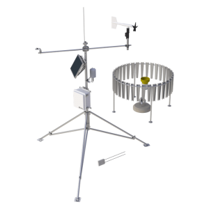
The GRWS100 is a mid-level, low-power, portable weather station with a tiltable mast. It makes general meteorological measurements but is flexible enough to be adapted to a wide variety of weather-based applications. The GRWS100 can calculate many related weather parameters such as evapotranspiration, growing degree days, wind chill, dew point, and more.
You can enhance an existing research project or meet the needs of a new project by adding sensors, control devices, and telecommunication devices to the standard GRWS100. Most of the weather stations we sell are customized. Tell us what you need and we’ll help you configure a station that meets your exact needs.
The SkyVUE™8 LIDAR Ceilometer is ideal for measuring cloud base heights and vertical visibility at airports, helipads (onshore or offshore), and other meteorological applications. The SkyVUE™8 measures the atmosphere with high stability and repeatibility, providing you with information on cloud base heights, sky condition (up to five layers), vertical visibility, and raw backscatter profiles. Notably, the ceilometer meets or exceeds all the necessary ICAO, CAA, and WMO requirements and recommendations.
Because of its robust construction, the SkyVUE™8 only requires minimal maintenance and can be continuously used in either static or mobile applications in harsh environments. Its compact design and low weight of 18 kg make it easy to transport and deploy.
With an operational reporting range of 8 km, the SkyVUE™8 has one of the highest in its class. It is easy to use yet features advanced signal processing and unique optics to provide superior resolution and performance.
The SkyVUE™8 has many standard features, from a tilting base and two-axis inclinometer for automatic correction of cloud base heights to heaters, blowers, and a sun filter for operation under all conditions—making deployments possible around the world.
Unique standard features include an easy-to-operate stratocumulus calibration, long-life back-up battery, and twin clocks to augment its many continuous diagnostic self-checks and provide assurance of continuous, reliable, and accurate performance.
The SkyVUE™PRO LIDAR ceilometer measures cloud height and vertical visibility for meteorological and aviation applications and is ideal for long-term research applications where a high level of detail is required.
Its robust construction is ideal for long-term installation, as it requires minimal maintenance and features a unique stratocumulus calibration procedure—allowing the ceilometer to be calibrated in the field.
The SkyVUE™PRO complies with CAA, WMO, and ICAO guidance and meets or exceeds all recommendations and specifications, including CAP437, CAP670, and CAP746.
With an operational reporting range of 10 km, the SkyVUE™PRO is easy to use yet boasts advanced signal processing and unique optical arrangements to provide superior resolution and performance.
The SkyVUE™PRO has many standard features, from a tilting base and two-axis inclinometer for automatic correction of cloud heights to heaters, blowers, and a sun filter for operation under all conditions—making deployments possible around the world.
Unique standard features include an easy-to-operate stratocumulus calibration, long-life back-up battery, and twin clocks to augment its many continuous diagnostic self-checks and provide assurance of continuous, reliable, and accurate performance.
Pilots as well as airline companies need to know the flight meteorological conditions for take-off , en-route and landing.
Weather information is essential to the safety and regularity of air navigation. Severe weather conditions can lead to flight delays, disasters and human losses.
Weather information is necessary at each step of a flight:
Before the flight, the observed or expected weather may lead to delay the flight, change route, cancel the flight.
For take-off and landing, the pilot must be informed of poor visibility on the runway, gust wind, wind shear, heavy precipitations…
Along the flight path, the pilot must be informed in advance about turbulence areas, location of cumulonimbus clusters, jets (strong winds), the risk of icing, volcanic ash, warnings issued by the Met services of the countries overflown during the flight.
To be able to provide an exhaustive briefing on current and forecasted weather conditions, the Airport Meteorological Service needs a Pilot MET briefing system.
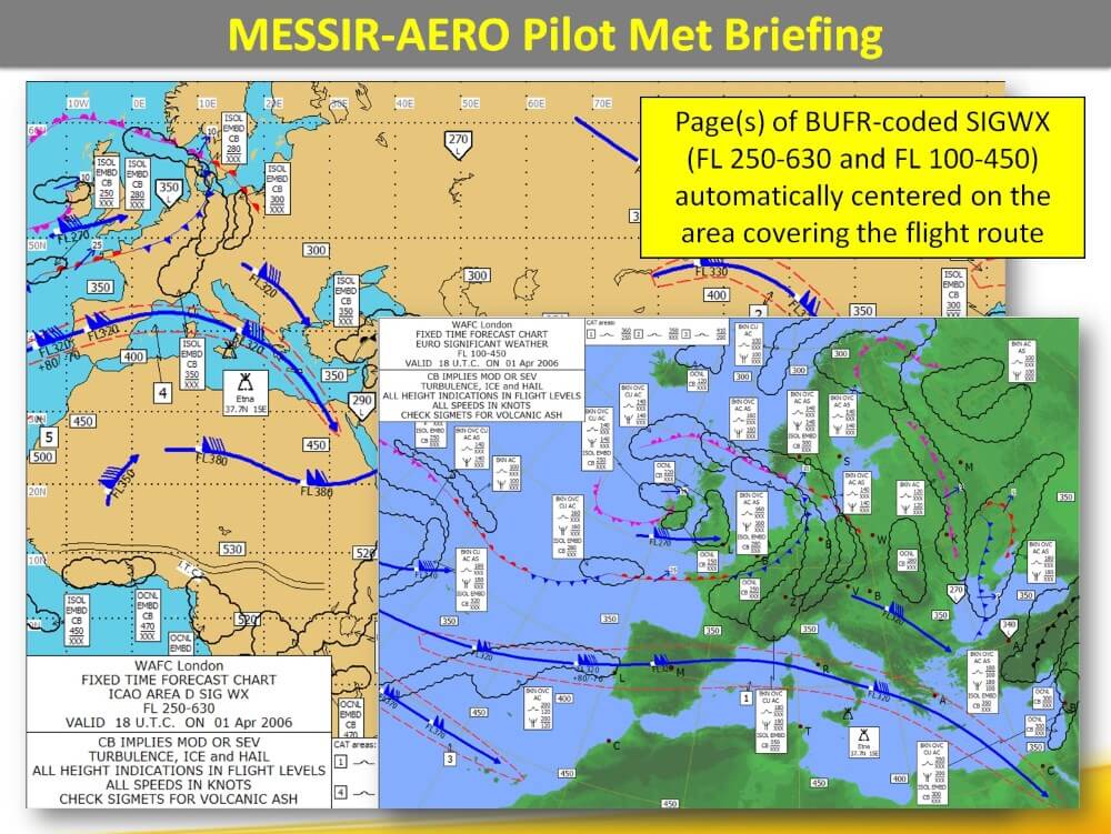
What is MESSIR-AERO?
MESSIR-AERO is the ideal Pilot MET briefing system.
MESSIR-AERO software allows the most demanding Airport Meteorological Services to:
Acquire SADIS WAFS data from WAFC London
Acquire WIFS WAFS data from WAFC Washington
Acquire other useful data and products from various data sources (MSS as MESSIR-COMM, local AWOS, satellite and radar imagery, wind shear alerts)
Store these data online to keep them at the immediate disposal of Pilots and Airline companies
Produce automatically Meteorological Flight Folders
Your needs
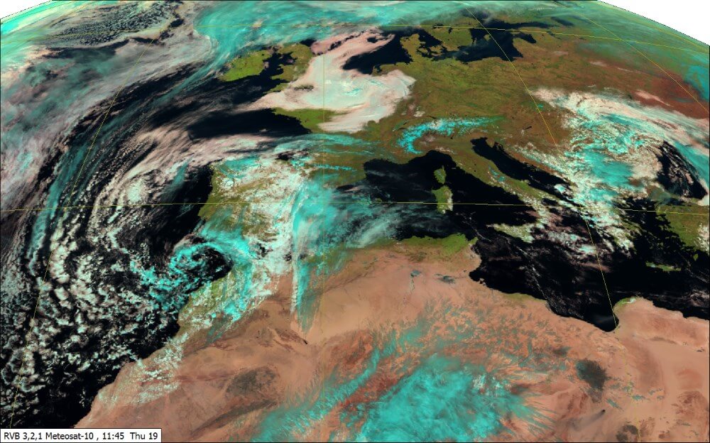
The high definition satellite images are an essential tool for forecaster, for weather analysis, monitoring and nowcasting. It allows to locate the main cloud masses (storm systems, tropical cyclones …) and to identify the type of clouds. The animation of these images also provides a clear insight of the evolution and the movement of the cloud masses.
Satellite imagery helps detect and forecast high impact weather, such as thunderstorms or fog.
All stages of convection can be monitored, from the initial instability in the atmosphere, to the development and properties of mature thunderstorms. Volcanic ash clouds, which are important for air traffic management, can be detected.
Weather forecasting centres need satellite imagery to perform their duty.
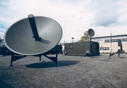
The MOBILE MET PLATFORM has been designed and adopted as theatre MET centre. In case of force projection, it enables work of the forecasters and guarantees an optimum quality of meteorological briefing to pilots.
The French Air Force and the French Army chose the MESSIR systems developed by COROBOR because of their established reputation as high performance systems in the world of meteorology and their fully integrated configuration.
Weather has an impact on most of human activities such as transportation, construction, military activities, agriculture, and fishing. Accurate weather forecasting improves human life, property and natural resources protection.
MESSIR-VISION is a sophisticated software for the forecasters. Allowing to:
Acquire real-time data and products from various data sources.
Store these data online to keep them at the immediate disposal of forecasters.
Provide them with a rich set of on-screen tools to produce forecasts, issue warnings and take decisions.
Disseminate forecasts/warnings to users.
This Forecaster Workstation runs on a standard Windows PC, which may include up to 4 screens. MESSIR-VISION integrates into one compact system all data needed for weather forecasting: surface and upper-air observations, numerical weather predictions (models), satellite and radar imagery…
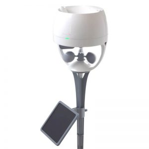
Compact, integrated multi-sensor weather station delivering high-quality meteorological measurements with minimal maintenance and low power consumption.
Meteorological thermometers are used for measuring the temperature of the atmosphere and are primarily in the form of maximum and minimum or normal reading thermometers. Sheathed screen thermometers are made to BS692 standard for use in a Stevenson's screen.